In pipeline risk management, it is crucial to continuously advance methodologies to ensure asset integrity and the safety of surrounding communities. In this context, GIE has developed a consequence assessment analysis that represents an innovative approach compared to usual practices, which typically define «affected zones» within a potential impact radius without considering dynamic factors.
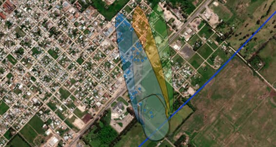
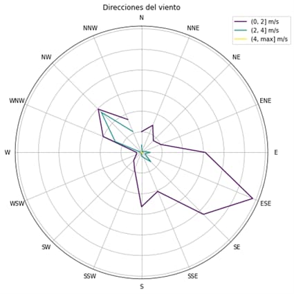
This analysis takes into account not only immediate ignition conditions but also delayed ignition scenarios, allowing for more accurate determination of affected areas for each scenario. Additionally, it includes simulations under specific weather conditions, integrating variables such as wind direction and speed, which are then projected onto detailed geographic maps. This approach considers how the orientation of residential structures relative to the pipeline and prevailing wind directions can significantly alter the risk assessment results.
Advantages of the Approach and Methodology
The methodology implemented in this study offers several advantages over traditional practices. Firstly, the detailed consideration of weather conditions not only improves the accuracy of the analysis but also allows for the identification of high-risk areas that may not be apparent in a more simplistic analysis.
For example, in areas where the population is predominantly on one side of the pipeline, preferential wind directions could drastically change the risk profile, affecting both the likelihood of ignition and the severity of the consequences.
Secondly, the use of advanced simulations also enables more realistic modeling of pipeline rupture scenarios. This analysis considered multiple variables, including gas pressure and pipeline diameter, which directly impact the extent and severity of affected areas. This results in a more robust study that can lead to more effective mitigation decisions.
Below is a typical case using this new methodology.
Analysis Development
The consequence assessment is developed through several key stages:
Data Collection: At this stage, detailed data on the pipeline is obtained, including its location, physical characteristics, and operating conditions. Additionally, demographic and geographic data of the surrounding areas are considered, with a special emphasis on the proximity of inhabited areas and critical structures.
Scenario Simulation: Taking into account the information collected, rupture scenarios are modeled using simulation tools that consider both immediate and delayed ignition. This modeling includes the simulation of flammable gas dispersion under different wind conditions, allowing for a detailed analysis of the potential impact under various wind directions and speeds.
Geoprocessing and Evaluation: The results of the simulations are geographically projected using geoprocessing software to evaluate the impact of the analyzed events on different inhabited areas. This stage of the analysis is crucial to identify the most vulnerable areas and quantify the consequences in terms of damage to infrastructure and risk to human life.

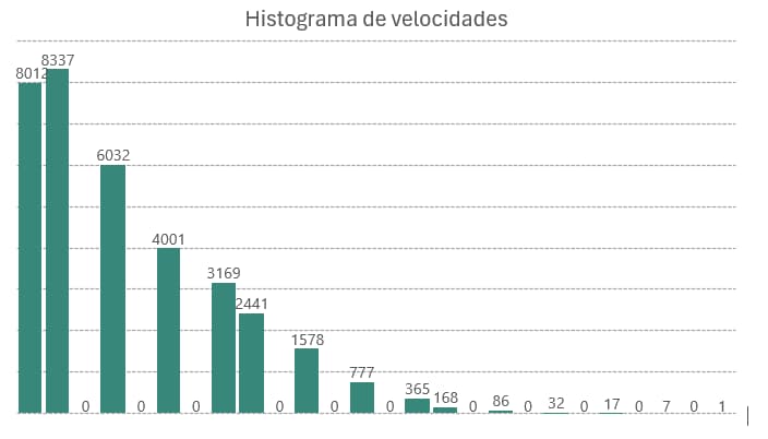
Meteorological Data Integration: Historical and projected meteorological data are incorporated to determine the most likely weather conditions during a possible rupture event. This integration allows for a more accurate assessment of the consequences, considering seasonal variability and prevailing wind directions.


Wind Speed Histogram
Conclusions and Practical Application
This consequence assessment analysis demonstrates the importance of integrating advanced techniques and simulation tools in pipeline risk management, especially those near inhabited areas. The ability to model different rupture scenarios and consider climatic and geographic variables allows for a more accurate and detailed risk assessment, essential for effective decision-making.
In this way, scenarios that might otherwise be ignored or underestimated in our risk analysis are considered and evaluated.
From a practical perspective, this approach can be adopted by pipeline operators and risk managers as a key tool to improve the safety and integrity of their systems. Identifying high-risk areas and implementing specific mitigation measures can significantly reduce the consequences of a potential failure, protecting both the population and critical infrastructure.
Author’s Reflection
I am convinced that innovation in risk management is not just a matter of technology, but how we use that technology to improve our methodologies and daily practices. This project reflects GIE’s ongoing commitment to improving risk assessment processes, using advanced tools to achieve more precise, highly reliable results.


